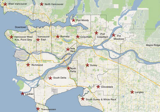
About Vancouver and Area
Vancouver, officially the City of Vancouver, is a coastal seaport city on the mainland of British Columbia, Canada. The 2011 census recorded 603,502 people in the city, making it the eighth largest Canadian municipality.The Greater Vancouver area of around 2.4 million inhabitants is the third most populous metropolitan area in the country and the most populous in Western Canada. Vancouver is one of the most ethnically and linguistically diverse cities in Canada; 52% of its residents have a first language other than English.Vancouver is classed as a Beta global city. The City of Vancouver encompasses a land area of about 114 square kilometres, giving it a population density of about 5,249 people per square kilometre (13,590 per square mile). Vancouver is the most densely populated Canadian municipality, and the fourth most densely populated city over 250,000 residents in North America, behind New York City, San Francisco, and Mexico City.
BC Communities: Vancouver, Coast & Mountains Region
ABBOTSFORD
The city of Abbotsford is one of the fasted growing areas in Canada. It is bounded by the Fraser River on the north and the U.S. border on the south. Abbotsford is one of the most productive agricultural areas in Canada and offers the visitor a wealth of recreational opportunities. Centrally located in the Fraser Valley along Highway 1. Abbotsford can be easily accessed from all directions; just 72 km (43 mi.) from Vancouver, 3 km (2 mi.) from the U.S. border and 68 km (40 mi.) from Harrison Hot Springs.
BOWEN ISLAND
Bowen Island is located 12 miles Northwest of Vancouver in the entrance to Howe Sound. It is a short, relaxing, 20-minute ferry ride from Horseshoe Bay in West Vancouver. Since the early 1900’s Bowen has been a favourite destination for Vancouverites looking for a quiet retreat or a place to get together with friends.
BURNABY
Incorporated in 1892, Burnaby, was at that time an agricultural centre. As it grew it transformed from a farming area to a residential community. Today it's the most heavily populated district in Greater Vancouver. Burnaby is on Hwy 99A, 12 km (7 mi) east of Vancouver. Main entrances from Hwy 1 are Grandview Hwy, Sprott Street, Willingdon Ave. and Cariboo Interchange. Activities include tennis, golfing, wildlife viewing, fishing, boating, museums, theatre, shopping and dining. There are numerous motels and hotels, as well as bed and breakfast places and RV parks for campers.
CHILLIWACK
Chilliwack is on the Trans Canada Highway, just 92 km (57 mi.) east of Vancouver and 50 km (31 mi.) west of Hope. Camping, swimming and hiking are just a few of the activities that can be done at nearby lakes, such as the popular Cultus Lake. A haven for fishers and boaters alike it offers all manner of water sports. The mountains draw bikers, hikers and campers. Chilliwack hosts a variety of festival during the year offering live theatre, music and dance.
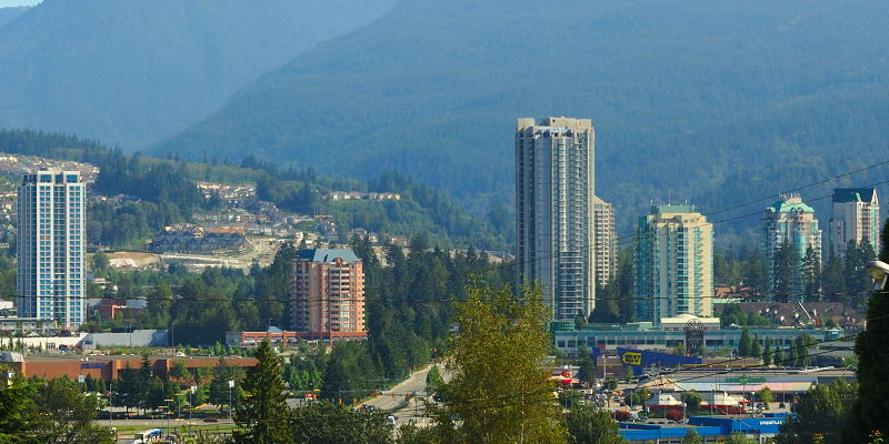
COQUITLAM
The Tri-Cities area of Coquitlam, Port Coquitlam and Port Moody, is a fast growing area within the Greater Vancouver District. Offering a relaxed suburban lifestyle the Tri-Cities is attracting new residents and businesses. Located approximately 30 km (19mi) east of Vancouver, the area offers golfing, curling rinks, skating/hockey rinks, swimming pools, hiking, biking, fishing, and a number of recreational centres. Visitors will find motels, hotels, bed & breakfast, and RV Parks.
DELTA
Delta and Tsawwassen are ideally located in the southwest corner of the Lower Mainland, bordered on the north by the Fraser River, on the south by Boundary Bay and on the east by the City of Surrey. The name "Delta" itself is derived from the fact that the community is located at the delta of the Fraser River. Delta is only 22 km (14 mi.) southwest of Vancouver via the Oak Street Bridge and the Deas Island Tunnel. The community is crossed by both Highways #99 and #91 which provides easy access to both the Vancouver International Airport and the U.S.
GIBSONS
The Town of Gibsons is a thriving community known as the 'Gateway to the Sunshine Coast'. Part of the mainland of British Columbia, the community is accessed by a scenic 40 minute ferry trip from Horseshoe Bay through beautiful Howe Sound.
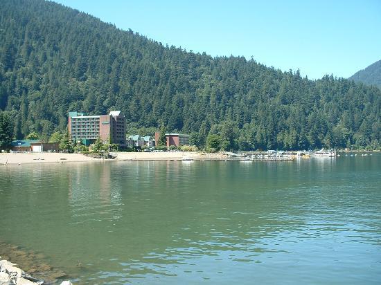
HARRISON HOT SPRINGS
Located at the southern tip of Harrison Lake, north of Agassiz, the name Harrison Hot Springs has long been assocciated with recreation and relaxation. Offering a world class resort, complete with bubbling hot pools, golf, dining and entertainment, Harrison has been a favourite for honeymoons, wedding anniversaries and romantic getaways. Visit quaint little shops, stroll along the beach, rent a boat or hike the trails. A variety of accommodations and campgrounds are located in the area.
HOPE
Hope sits on the banks of the mighty Fraser River surrounded by the towering Cascade Mountains. This picturesque small town is strategically located at the junctions of Highways #1, #3, #5 and #7, so it offers a wide variety of accommodations, services and recreation opportunities. Travellers heading north and east can definitely look upon Hope as a gateway to outdoor adventure. They will find a golf course, camp grounds, fishing, hang gliding, mountain biking, hiking, skiing, gold panning, rock hounding, whitewater rafting, and fishing.
HORSESHOE BAY
Horseshoe Bay serves as the terminus for BC Ferries to Departure Bay in Nanaimo on Vancouver Island, to Bowen Island and Langdale on the Sunshine Coast. It is also the starting point of the Sea to Sky Highway that hangs on cliffs as it winds its way along Howe Sound to Squamish, Whistler and Pemberton.
LADNER
Both Ladner and Tsawwassen are part of the Municipality of Delta. Located in the south west corner of mainland B.C., these two urban centres are separated by very fertile land. Ladner, a community on the river, is older than Vancouver. Tsawwassen, is where the B.C. Ferry Terminal is located. Ladner is a few minutes from Hwy 99 that goes from the Canada/US border through Delta, on to Vancouver and Burrard Inlet. Tsawwassen is on Hwy 17, just 14Km (9 mi) southwest of junction Hwy 99. There's super windsurfing off the ferry spit; water slides; bird watching; beaches and river front walkways.
LANGLEY
Bustling civic development and a beautiful pastoral landscape make the community a fine place to live and to visit. Stretching from the south bank of the Fraser River to the U.S. border, Langley actually refers to two municipalities: The City of Langley and the Township of Langley. The visitor should not leave the area without a visit to Fort Langley, British Columbia's birthplace. The community offers not only cozy cafes, quaint shops, galleries and stores but also a historic component that is fascinating. Langley is located 45 km (28 mi.) east of Vancouver and can be accessed from Highway 1 or Highway 10.
LUND
The gateway to world-famous Desolation Sound, the waterfront Hurtado Point Trail, and the Ragged Island Provincial Marine Park. Located approximately 28 kilometres North of Powell River, on the Sunshine Coast, the drive to Lund is scenic and takes about 1/2 hour of easy driving. Lodging includes cottages, hotel, resorts, campground, and cabins.
MAPLE RIDGE
In the shadows of the majestic Golden Ears and alongside the mighty Fraser River, Maple Ridge plays host to a variety of recreational opportunities. Maple Ridge is 42 km (26 mi.) east of Vancouver on Highway 7. Recreational facilities and activities include golf courses, Golden Ears Provincial Park, Kanaka Creek Regional Park, camping, horseback riding, biking, hiking, boating, fishing, and sightseeing
MISSION
In the heart of the Fraser Valley is Mission, named after St. Mary's Mission, founded in 1861. The surrounding lakes and mountains provide fishing, hiking, camping and skiing for the outdoor enthusiast. Access from Vancouver is either along the TransCanada Highway and turning north at Abbotsford or following Highway 7 (71 km/44 mi.). There are a number of hotel/motel accommodations in town plus private and provincial campsite close by.
NEW WESTMINSTER
Founded in 1859, and named by Queen Victoria, "the Royal City", New Westminster was B.C.'s first capital city. Nestled on the banks of the Fraser River, the city retains its old time charm, with heritage lined streets and a quaint, homey atmosphere. New Westminster is only a short SkyTrain ride away from Vancouver (25 km/16 mi.). It is adjacent to the Trans Canada Highway 1 and the Alex Fraser Bridge. Situated within 32 km (20 mi.) of the U.S. border, the ferry terminal to Vancouver Island, passenger rail stations and the Vancouver International Airport, NewWestminster is very easy to get to.
____________________________________________________________________________
Vancouver Island
"Quadra and Vancouver Island" redirects here. For the nearby island named solely after the Spanish explorer, see Quadra Island.
Vancouver Island, located in British Columbia, Canada, is the largest Pacific island east of New Zealand. Originally called Quadra and Vancouver Island after Spanish navigator Juan de la Bodega y Quadra and British navy officer George Vancouver, the island was first explored by British and Spanish expeditions in the late 18th century. The former's name was eventually dropped and it has since been known solely as Vancouver Island. It is one of several North American locations named after this British Royal Navy officer who explored the Pacific Northwest coast of North America between 1791 and 1794. While the city of Vancouver is located on the North American mainland, Victoria, the capital of British Columbia, is located on the island.
Along with most of the southern Gulf Islands, plus various minor islands offshore from its southern end, it is the only part of British Columbia (and Western Canada) that is south of the 49th Parallel. It has the warmest climate in the country and since the mid-1990s has been mild enough in a few areas to grow subtropical Mediterranean crops such as olives and lemons.
NORTH VANCOUVER
Overlooking Burrard Inlet, backed by the Coast Mountains is some of the Lower Mainland's best scenery. North Vancouver's waterfront was one of the first on the Lower Mainland to be developed and still remains a very active port area. North Vancouver, on Hwy 99 is only 8km (5mi) north of Vancouver. To cross Burrard Inlet, take the Second Narrows Bridge, the Lions Gate Bridge or the Sea Bus from downtown Vancouver. Favourite activities include hiking; biking; good down hill and cross country skiing; fishing; a petting farm; forestry tours; dining; as well as shopping.
PEMBERTON
Pemberton is a small and vibrant community of 2,500 people and covering 320 hectares of land. The Village is the service centre for 6,000 people which includes the communities of Pemberton, Mt.Currie, Birken and D'Arcy. The Pemberton Valley is situated 159 kilometres north-east of Vancouver, British Columbia. The Village of Pemberton is a driving distance of about 2.5 hours north of Vancouver, BC, 1.25 hours north of Squamish and 20 minutes north of Whistler on the scenic Highway 99.
Port Coquitlam is a city located 27 km (17 mi) east of Vancouver, it sits at the confluence of the Fraser River and the Pitt River. Coquitlam borders it on the north, the Coquitlam River borders it on the west, and the city of Pitt Meadows lies across the Pitt River, beyond with is the city of Maple Ridge. Port Coquitlam is almost entirely bisected by a Canadian Pacific Railway yard with two underpass crossings and one overpass. Port Coquitlam is often referred to as "PoCo." It is Canada's 88th largest city by population.
Port Coquitlam is not to be confused with the adjacent and larger Coquitlam.
POWELL RIVER
Powell River is 31 km (19 mi.) north of Saltery Bay Ferry Terminal on Highway 101. It is served by BC Ferries from Powell River to Comox and Texada Island. The route to Comox is a distance of 27 km (17 mi.) by sea, with a crossing time of one hour and 15 minutes. The Upper Sunshine Coast, where Powell River is located, is a blend of majestic coastal range, numerous forested islands, and seascapes and history. Golfing, hiking, scubadiving, canoeing, fishing, hikers, wildlife viewing, photography, and swimming are all popular activities.
RICHMOND
Richmond is your gateway to British Columbia and home to the Vancouver International Airport. The community of Richmond is ideally located just a short jaunt from the US/Canada border, downtown Vancouver and BC Ferries. Whether it’s your final destination, or a stopover, Richmond’s diversions are plentiful. Visit the Historic Fishing Village of Steveston and you will be hooked on its charm, or get immersed in the Asian culture of the Golden Village. With an exceptional range of accommodations, parks, attractions, international culture, cuisine, shopping and more, a stay in Richmond is an experience to remember!
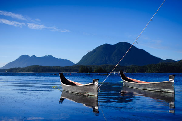
SECHELT
The area from Gibsons to Lund and Desolation Sound Provincial Park is known as the Sunshine Coast. The area is aptly named because of its predominantly sunny weather but it is more than just the sunshine that attracts residents and visitors alike.
SURREY
Surrey offers a unique diversity of urban amenities and spacious countryside. Parks, beaches, cowboys, shopping, history, arts and culture; Surrey has something to offer everyone. With over 200 parks, there is plenty of space to walk, cycle, explore or swim. Surrey is 40 km (25 mi.) east of Vancouver on Highway 99A. There are a wide range of hotel and motel accommodations available plus two RV parks and campgrounds.
SQUAMISH
Driving Highway 99 north of Vancouver (60 km /37 mi.) will bring you to Squamish. On the way, you'll pass the Horseshoe Bay B.C. Ferry terminal and some of the world's most breathtaking stretches of oceanside road, on the Sea to Sky Highway (99). Local activities include rock climbing, fishing, camping, hiking, mountain biking and golfing. You'll enjoy a visiting the area's many parks, waterfalls and beaches.
Meaning "facing the ocean") is a suburban, mostly residential community located on a peninsula in the southwestern corner of the Municipality of Delta, British Columbia, Canada. Tsawwassen provides the only road access to the community of Point Roberts, Washington via 56th Street. It is also the location of BC Ferries' Tsawwassen Ferry Terminal, built in 1959 to provide foot-passenger and motor vehicle access from the Lower Mainland to the southern part of Vancouver Island and the Southern Gulf Islands. Because Tsawwassen touches a shallow bank, the ferry terminal is built at the southwestern end of a 3 km-long causeway that juts out into the Strait of Georgia. The ferry dock and causeway are part of Highway 17.Boundary Bay Airport, a major training hub for local and international pilots, in addition to providing local airplane and helicopter service, is located ten minutes away. The Roberts Bank Superport is also located near Tsawwassen.
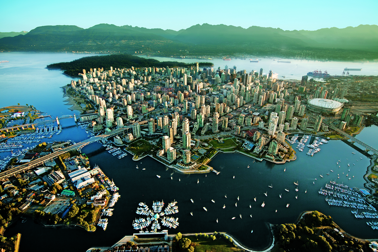
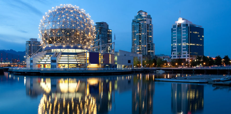
VANCOUVER
Vancouver is world-renowned for its breathtaking natural setting and a cosmopolitan flair, complimented by parks, gardens, beaches plus a variety of cultural and recreational facilities. Vancouver is located 40 km (25 mi.) east of the Tsawwassen Ferry Terminal on Highway 99. The ferry gives you access to Vancouver Island while Highway 1 (Trans Canada Highway) takes you through the Fraser Valley and points east and north. The US border is a mere 40 minute drive to the south. Greater Vancouver is also served by an international airport, rail and bus lines.
WEST VANCOUVER
One of Canada's most picturesque residential areas. Bordered by Burrard Inlet to the south and Howe Sound to the west, West Vancouver is along the lower slope of Hollyburn Mountain that's between Capilano River valley and Horseshoe Bay. West Vancouver is just west of Lions Gate Bridge, that crosses Burrard Inlet via Hwy 99. or cross the Inlet via the Second Narrows Bridge on Hwy 1. From Vancouver Island take one of the many B.C. Ferries to Horseshoe Bay. There are hotels and motels as well as good camping sites.
WHISTLER
The resort municipality of Whistler is an unparalleled year-round destination resort, less than a two-hour drive from Vancouver. Whistler Resort is more than just world-class skiing, its Coast Mountain setting offers visitors a wide variety of both winter and summer activities: golf courses, 2 world class ski mountains, downhill ,cross country and heli-skiing skiing, ice skating, snowmobiling, hiking, swimming, fishing, boating, biking; photography, sightseeing, camping. Whistler lies 120 km (74 mi.) north from Vancouver or 44 km (27 mi.) north of Squamish on the scenic Highway 99.
WHITE ROCK
White Rock, is a colourful and yet quaint community situated on beautiful Semiahmoo Bay. It draws it's name from the very large white rock on the beach. Visitors enjoy walking the pier and strolling the promenade that runs for 4.5km (4 mi) on the beach-front. Bring your swim suit. Long stretches of sand and pastel ocean views attract visitors to this popular seaside location. The shopping is great, and you won't want to miss the many little shops that offer everything from Old English style fish & chips to works of art. White Rock is located 45km (28 mi) southeast of Vancouver on Hwy 99.
_______________________________________________________________________
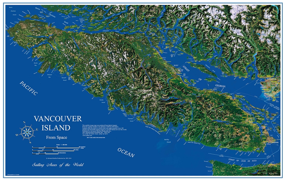
The island is 460 kilometres (290 mi) in length, 80 kilometres (50 mi) in width at its widest point, and 32,134 km2 (12,407 sq mi) in area. It is the largest island on the West Coast of North America, the world's 43rd largest island, Canada's 11th largest island, and Canada's second most populous island after the Island of Montreal. The Canada 2011 Census population is 759,366.[6] Nearly half of these (344,630) live in Greater Victoria. Other notable cities and towns on Vancouver Island include Nanaimo, Port Alberni, Parksville, Courtenay, and Campbell River.
The island was originally named Quadra's and Vancouver's Island in commemoration of the friendly negotiations held by Spanish Commander of the Nootka Sound settlement Juan Francisco de la Bodega y Quadra, and British Naval Captain George Vancouver on Nootka Sound in 1792, to find a solution to the Nootka Crisis.